Hancock County Historical Society
County History
County History
Overview of Hancock County History
Hancock County inhabitants far pre-date the arrival of the first white man and long before it had its name. Evidence exists that this land had inhabitants even before the red-skinned people calling themselves, “Illini” for which our great state received its name. Even as this is written, new discoveries about our county are being made through ongoing research by various groups that perform archeology.
The history of the county as we know it begins with the arrival of the white men, known to us as the French explorers and fur traders. Eventually the pioneers arrived and cleared the land, built forts and homes. In the earliest days they settled along the Mississippi River that served as the major transportation mode and also a good water source needed for survival. Fish and wild game were plentiful to include wild turkey, deer, rabbit and other meat sources. There was also sufficient timber needed for building the early settlements. In the years 1812 – 1818, the population of the state increased and fifteen counties had been formed. Madison County contained one-third of northern Illinois. Fort Edwards, now Warsaw, added enough “souls” to the state’s population to reach a goal of 40,000 in 1818 that was needed for Illinois to become a state through the enabling act passed by Congress. The county underwent a series of transformations before becoming a separate county named “Hancock”.
Hancock County is located about forty miles north of the center of the state, on its west line, and within what was known as the “Military Bounty Land Tract.” Adams County line is to the south, McDonough and Schuyler to the east and Henderson to the north. Its western boundary is the channel of the Mississippi River. Directly across the river and to the north is the state of Iowa and across the river to the south is the state of Missouri. The county is 30 miles long, 24 miles wide and constitutes 795 square miles.
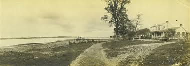
Waggoner Point in Montebello Township — settled in 1824 by John Waggoner
It contains 25 townships that were designed to be 6 square miles each although due to the irregular nature of those with boundaries on the river, there are a few exceptions. The central part of the county is composed of prairie land and rich soil needed for productive agriculture. “Crooked Creek” (a.k.a. LaMoine River) and Bear Creek provide needed water to the pioneers who settled inland.
The county also contains rich sources of limestone found along the river bluffs in the county from Henderson County on the north, to the town of Warsaw to the south. . Today, visitors delight in seeing the replication of the original Nauvoo Mormon Temple which historical accounts report as built of this limestone.
As early as 1840 or ’41,’ a deposit of geodes was found in the vicinity of the now non-existent village of Montebello, north of the present town of Hamilton. Today, rock collectors still find fascination with these, and other rocks and fossils found in the area. Tourists will also find Eagle watching near the Mississippi River Bridge between Hamilton, IL and Keokuk, Iowa in the winter months. In mid January the tri-state area hosts a celebration of not only the eagle watching, other forms of river wildlife, and also Native American culture and a variety of related arts and crafts.